Jack's Blowhole
Beez Neez now Chy Whella
Big Bear and Pepe Millard
Thu 31 Jul 2014 22:57
|
Jack's Blowhole   After our unscheduled stop at Cannibal Bay
we followed the Wicked Witch’s instructions along the gravel road and over the Catlins River.
 Soon we saw Jack’s Bay.
xx xx
 You-know-who got a fit of the giggles when he saw the sign to
‘watch for children’. We are used to seeing kiwi,
penguin, sheep, skid, snow, ice and all manner of other warnings. Well it just
tickled me. Yes dear........
 We
did take care and drove the last bit very slowly. There is a
small group of holiday homes near the beach which must be gorgeous mid
summer. Not even a paddle from us,
far too cold for that. In fact no one else here but
us.
 Not absolutely certain
what Jack’s Blowhole is, but twenty minutes seems a
reasonable tramp to find out.
 Later on we found out.
Here is the Google map of the
tramp.
 The first bit took us
on a gravel path past some interesting trees. Twenty minutes was a bit shy of
the truth as it turned out and we did have to negotiate some very steep, wet,
muddy bits. Why oh why didn’t I have my welligogs on, no
doubt and yet again, to keep them in pristine condition. Well they
are rather smart aren’t they. Yes
dear.....
  As with the bay and nearby island, Jacks Blowhole is named after the famed Ngāi Tahu chief,
Tuhawaiki, known to early European settlers as Bloody Jack - apparently he was
fond of using the expletive. After losing a battle with one of Te
Rauparaha's scouting parties at Cannibal
Bay, he was trapped with his men on False Island. Tuhawaiki
escaped by leaping from the cliffs into the sea and swimming eight kilometres to
Tuhawaiki Island.
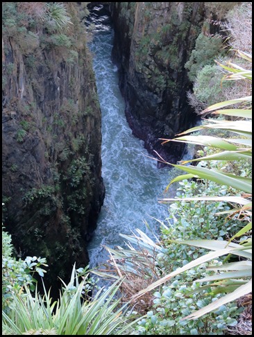
 The blowhole is in Tunnel Rocks Scenic Reserve, it was
formed when the roof of a large subterranean cave was eroded by the sea and fell
in. This is an exposed coastline and heavy swells from the southern ocean can
create an impressive display. The waves are compressed through the underground
tunnel and explode into the blowhole.
 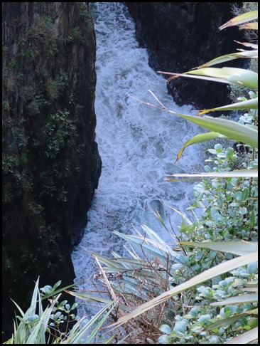 There was plenty of roaring sound effects from both the
water and the onrush of air, created by the surge from the
sea expelling the air from the tunnel. Apparently, the best time to be
here is at high tide with an onshore wind, nonetheless we were glad to be here,
if nothing else because it is called Jack. We waited on the viewing platform for
half an hour or so and then made our way back to
Mable.
  Halfway back we stopped. The track ahead and behind us looking
toward Jack’s Blowhole.
 There were lovely views from up here; the broad sweep of
the coastline down to Penguin Bay to our
right.
 The amazing thing about New Zealand is how quickly views change.
  Bearing left we
could once again see Jack’s Bay.
  The route to the blowhole is marked by painted poles and a couple of stiles. That’s the one that I got an ingress at....grrrrrr.
A rather handsome thistle.
Safely back to Mable ankles intact, we had our sandwiches with Jack’s Bay.
Back on our way.
Such greenness.
ALL IN ALL THE NOISE WAS GOOD A BIT DISAPPOINTING BUT IT WAS VERY DEEP |


